

The young woman who gave us a tour (in Spanish) did tell us the inner courtyard was where the dangerous criminals were kept and they were not allowed to leave. She also showed us where some of the guards used water torture on some of the prisoners and it made them crazy.


The prison housed females in the front rooms.


The prison housed females in the front rooms.

The picture of Our Lady of Guadalupe was painted by one of the female inmates. Inmates were housed here from as far south as Cabo San Lucas and it was used until 1975 when a new facility was built just south of Santa Rosalia. We passed the new prison on our way north today.
We again went through areas of diverse vegetation. We found a spot to pull off and get a good look at one of the elephant trees and several different flowers.

We again went through areas of diverse vegetation. We found a spot to pull off and get a good look at one of the elephant trees and several different flowers.

We were told the white flowers are a “prickly poppy.” The spine is covered with stickers. The purple flowers reminded me of mountain lupines, but we will have to check it out later. We also went through an area with datillo and cardon cactus.


We drove into San Ignacio, a town that is surrounded by date palms. Several of the trees, as well as buildings on the way into town were damaged or destroyed by the hurricane and the two RV parks were virtually non-existent. We did go into the Mission San Ignacio Kadakaaman which is located across from the town square.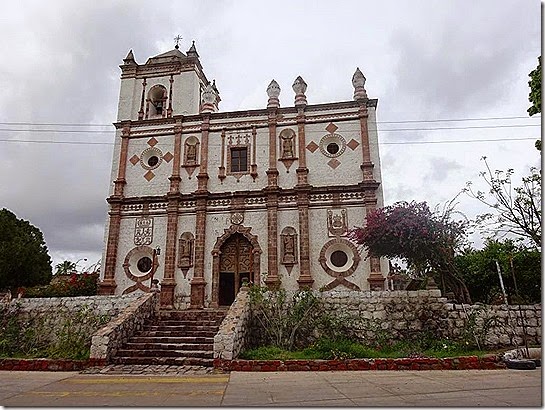
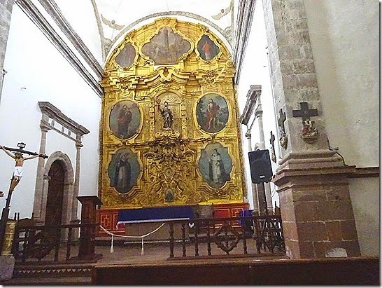


Construction of the stone mission started in 1760 and was completed around 1786. There are three carved and gilded wooden altar pieces that date from the end of the 18th Century. During the first part of the 19th Century, the indigenous people disappeared from this area as a result of epidemic diseases and cultural changes in their way of life. The mission stopped working and gave way to a different society formed by “mestizo” families that assured the national identity in this remote part of the country.
We had originally planned to camp at San Ignacio, but decided to continue further north to Laguna Ojo de Liebre, just south of Guerrero Negro. On the way, it did rain and the temperature dropped quite a bit. We passed through an area that had little sand dunes which seemed to just pop up against the landscape.
We had originally planned to camp at San Ignacio, but decided to continue further north to Laguna Ojo de Liebre, just south of Guerrero Negro. On the way, it did rain and the temperature dropped quite a bit. We passed through an area that had little sand dunes which seemed to just pop up against the landscape.

Approximately five miles south of Guerrero Negro is the turnoff to Laguna Ojo de Liebre. The first mile or so of the 25KM road is paved, then turns to gravel and packed dirt. 

The road winds through the flat desert and part of the salt-evaporation ponds which is one of the major industries in the area before arriving at the lagoon.

We were treated to a beautiful sunset and hope to catch a whale watching trip tomorrow if the weather warms a bit.


GPS 27.74816N, 114.01414W
RV CAMPING – BAJA CALIFORNIA SUR
RV CAMPING – BAJA CALIFORNIA SUR
2 comments:
I'm still catching up on your blog. I feel like I'm travelling along with you through your blog posts. I especially appreciate the GPS coords you include. A lot of the places are impossible to find by just searching for names. I need to make sure to include the GPS coords on my own blog entries.
We have found it helpful having the GPS coordinates, also. Hopefully they are pretty close - I tried to take the readings every night. We use a program from Microsoft "Streets and Trips" to map out our route. The unfortunate thing is they are discontinuing updates and support, so we will just continue to use our old version.
Post a Comment