
We stopped at the overlook coming into San Jose del Cabo – about 20 minutes down the road. We wanted to get one more look at the water before our journey took us inland!
 Saying goodbye to the beach, Hwy 1 turns inland and heads to the mountains.

At Km 82, we stopped at the Tropic of Cancer. When we were here 10 years ago, the globe in the picture below was painted white – although most of the paint was chipping off, and it was all by itself on the side of the road.


Now, there is a lovely pull off with a road-side chapel and shops. There is a marker in the front and you walk through an archway to the globe that is now painted and easy to identify. Notice the line marking the 23 degrees,28 minutes north of the equator.


A few kilometers down the road, we turned off to Santiago, the last real town before we would reach El Chorro Canyon and the Agua Caliente hot springs. We stopped for lunch at Palomar Restaurant because Tobey read that it was supposed to be so good. The service was good, the people were friendly, and the food was okay, but it wouldn’t warrant a return visit in our opinion. It’s funny how a place gets a reputation and every gringo follows suit!
Our Streets and Trips map didn’t have the road from Santiago to El Chorro, but the owner of the restaurant showed us a topo map and directed us to go past the zoo and continue for 15 kilometers or so. Tobey did have a Google map that he pulled up and had on the computer, so we also tried using that, but I am terrible without the GPS to know which curve we had just passed, so we both got a little testy before we finally arrived!
Our Streets and Trips map didn’t have the road from Santiago to El Chorro, but the owner of the restaurant showed us a topo map and directed us to go past the zoo and continue for 15 kilometers or so. Tobey did have a Google map that he pulled up and had on the computer, so we also tried using that, but I am terrible without the GPS to know which curve we had just passed, so we both got a little testy before we finally arrived!

Just outside of town the road turned to gravel – washboard gravel. Our top speed was about 5 mph! These mama cow and calf were along the side of the road – they probably could have outrun us, if they had tried!
 Well, we FINALLY did arrive - about 1-1/2 hours for the 15 km drive – and the road got much narrower than it was when we started! The best part of the drive was near the last curve in the road, a bobcat ran across the road in front of us. It was really cool!
The camping area is run by the local ejido (co-op farming group). It cost $140 pesos ($10 USD) to camp and use the hot springs. After setting up, we hiked down to the river and hot springs. We saw this bug – is it a spider or a other insect? We couldn’t tell, it was crawling on the ground and was BIG!!!

We waded across the river just downstream from the dam and hiked as far as we could – climbing over lots of boulders. We went as far as we could without scrambling up the hills, but apparently, there is a different trail that will take you to some waterfalls. Guess we missed that!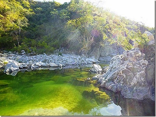
When we got back near the dam, there was a group that runs a bio-farm near here and they were working on rebuilding the hot pool area that was destroyed by Hurricane Odile in September. The hot water comes out of the rock wall along the right side of the picture so they were carrying huge rocks over to build a “hot tub”.

They really manhandled some HUGE rock to build a pool.

Tobey and I watched for a while, then we pitched in to help We shoveled gravel and sand, then helped carry filled buckets over to the hot tub area.

We worked until the sun started setting behind the hills, then we all relaxed a few minutes in the newly constructed “hot tub” as a reward!
They told us there used to be an area walled in with rock, but the hurricane wiped it out, as well as part of the dam. Also, before the hurricane the river was filled with cattails and other vegetation – now most of that was gone. Mother nature certainly is a powerful force!
There are a couple other Americans camped here, but it is really quiet. After a HOT, HOT day (seemed like 90), the evening cooled off and should be a quiet night’s sleep. No cell reception here for the Banda, so we will post when we can.
GPS: 23.44078N, 109.80600W
1 comment:
Wow, what an interesting place. That bug is just creepy.
Post a Comment