Travel with Tobey and Sue

Travel with Tobey and Sue
Tobey and Sue in Africa

Saturday, January 24, 2015

January 23, 2015 - Guerrero Negro to Vizcaino

Our whale watching trip was scheduled for 11 a.m. today, so we were able to take care of housekeeping details like dumping the tanks and refilling with fresh water.
We booked the tour through the RV park and it was $650 pesos per person (about $45 USD) for the 4 hour tour. We were afraid we wouldn’t be able to go – all three of their 8am boats were full, as well as their two 11 am boats. They opened a third boat and Tobey and I, along with an interesting young couple from Germany who are bicycling from Anchorage, Alaska all the way to Argentina, were the only people on the third boat! You have to get lucky once in a while!!
The drive to the docks went through town and our guide gave us some history of the area. Guerrero Negro is largely supported by the salt-producing industry. It was interesting to see the evaporation ponds which are supposed to be the largest in the world, along with the docks where they ship the commercial grade salt to the US , Japan, and Argentina. 2015 - 1-23 salt mineAfter arriving at the dock and getting settled into our panga, we zipped about 15 minutes out into Laguna Ojo de Liebre (Eye of the Jack Rabbit), which is one of the major breeding grounds for the California gray whale. The lagoon is more commonly called Scammon’s Lagoon, named after the American whaling captain who found the entrance to this lagoon in 1857. The California gray whale population was exploited and down to about 2000 whales at the turn of the century, but with international treaties and efforts from the Mexican government, the population is now estimated to be over 20,000 whales. The warm, calm waters are an excellent breeding ground for these whales who migrate from the frigid Alaskan waters in the fall.2015 - 1-23 whale watch 2
Researchers count the whales by a scientific method developed from the University of Oregon (we think). Anyway, the estimate is there are currently 650 adults and 400 babies in the lagoon. We certainly saw our share!2015 - 1-23 whale watch 3
Gray whales can get to be 45 feet long and weigh 35 TONS! The females are usually larger than the males. The baby above was watching us. The mama below is covered with barnacles. Most of the babies are only 3-4 weeks old right now.
2015 - 1-23 whale watch 6
We were really lucky to only have four of us and the captain in our panga – same size as the one pictured below. We were able to move around, always had a “window” seat! The whales came right up to the boats and swam under them, popping back up on the other side!!2015 - 1-23 whale going under the boat2015 - 1-23 whale watch 9a
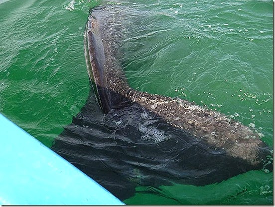
It was really an incredible experience – definitely the best whale watching experience we have ever had! We were allowed to touch the sides of the whales as they swam along next to the boat.
Unfortunately, the tour had to come to an end and as we said goodbye to the whales, they waved goodbye to us!2015 - 1-23 whale watch 5

Whale watching at Guerrero Negro
Skirting the shoreline on the way back to the dock, we saw lots of migratory birds, and some lazy sea lions sunning themselves on one of the lagoon anchor spots.2015 - 1-23 whale watch 8We arrived back at the RV about 3:15 and wanted to get a fish taco at the “El Muelle” truck, but they had already sold out and were closed up. We tried another stand, but the tacos were not very good. Oh well, the road going north in a couple months is the same one, so we will have to plan our time better!
GPS: 27.64633N, 113.38528W

Friday, January 23, 2015

January 22, 2015 - Catavina to Guerrero Negro, California Baja Sur

We left our camping area and drove about five kilometers to stop and see the “pinturas rupestres” (cave paintings) which are located near Km C-176). We hiked to them ten years ago and there were no trails then, and according to our guide book, there are still no trails. Not true. Between 2005 and now, the Mexican government built a museum, gallery and hiking trails. Well, the museum and gallery have fallen into disrepair, but there are beautiful hiking trails and signs, and arrows pointing the way to the cave! We parked near the abandoned museum and hiked back about .3 mile and followed the signs up the hill to the cave.


There are numerous red, black, and yellow paintings in the tiny cave. While these are not the largest (and some people say not the most awe-inspiring) of the Baja cave paintings, they are probably one of the easiest to reach. It was cool to see some of the culture of the Baja’s earliest inhabitants and we were glad we made the hike to see them again.

Back on the road, we continued through the boulder field and saw lots of cirio cactus. They always remind me of carrots, growing in reverse, roots in the air!
At Km C-180, we crossed an arroyos where there were groves of native Washingtonia fan palms – and even a little water crossing the road!

We also left most of the boulder field behind at this Km marker. Around Km C-210, we did pass by “El Pedregoso” . It is funny to read the guide book – it says, “On the right (west) side of the highway can be seen a hill of grotesquely shaped granite boulders It is named El Pedregoso (the rocky one). It is a boulder field in the process of development.” It didn’t seem that grotesque to us!

Near Km C-245 the highway passes through a large forest of cardon (giant cactus). There were more of the cirio cactus, as well.

The wind blew today … and blew! It was a tough drive for Tobey. This is the only highway through Baja California going north and south – Hwy 1. It is two lane, narrow, and most places have no shoulders or pullout areas. Fortunately, there is also very little traffic! On this stretch of wide road, we spotted some white burros. They didn’t mind us at all!

The huge flag below is at Km D-128, Paralelo 28, the State Line between Baja California and Baja California Sur.

Just past the flag, we had to pass through a military check point and agricultural inspection station. We were asked if we had any citrus fruit, which we don’t, and where we were heading (Cabo). Pay $20 pesos to have the undercarriage of the vehicle sprayed with insecticides and we are on our way.

We fueled up and are camped at Malarrimo Hotel and RV Park in town. It is $215 pesos ($14.85 USD) per night and includes water, electric, and WIFI (not very good). Amazing, the electric actually works for us! Tobey is feeling a little better, but certainly not 100%. Early to bed for him! We are signed up to go on a whale watch excursion tomorrow morning at 11, then will decide whether we stay another night or move on.

Thursday, January 22, 2015

January 21, 2015 - El Pabellon Beach to Ejido San de las Palomas turnoff - Catavina Boulder Field

The day started off cloudy and cool, with a strong wind off the Pacific. We followed the coast for a short distance before HWY1 curved inland and we said goodbye to our views of the Pacific. Near KM43, the highway started to wind its way uphill to a plateau before it descended rapidly into the little town of El Rosario.


We stopped at Mama Espinosa’s Restaurant for lunch and shared the lobster burritos, chips and soft drinks. It actually comes with 3 burritos and we split the plate! Cost including tip was $320 pesos ($13.50 USD). They were pretty tasty. We ate here 10 years ago and this was better than we remembered!

At KM65, just south of El Rosario, there is a fairly new .5 mile bridge that crosses the Rio del Rosario. While the river is currently dry, during the rainy season in late fall, the river apparently becomes a roaring torrent. We were thankful for the bridge!
After crossing the bridge, the highway passes though the mountains and plateaus of the westerly slopes of the Peninsular Range Mountains. The vegetation also changes to the Sonoran Desert vegetation. There were century plants, and many types of cactus including prickly pear, galloping cactus, candelabra, giant cardon, and the cirio cactus. We made a couple stops near KM85 to get some pictures.
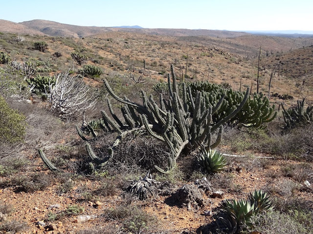
The cirio cactus below is tapered to the top, resembling a candle. Along the trunk are numerous branches, smaller than the diameter of a pencil and totally out of proportion to the plant as a whole. They have tiny leaves which are green, especially following rain. They can group up to 60 feet high!


Near KM163, we entered into the Catavina Boulder Field. It is probably the most scenic and interesting part of the Transpeninsular Highway. So here comes your geology lesson for the day. The thousands of rounded boulders are composed of granite rock. A mass of molten material was cooled slowly beneath the earth’s surface. Masses of granite rock tend to fracture vertically at the surface. The fractures are weathered by water and freezing temperatures (yes, it freezes here in the winter), and the rock mass breaks up into blocks. With further weathering, the blocks are rounded into the boulders. Pretty impressive.
Near KM165, we turned off the road onto a dirt road at the Ejido San Jose de las Palomas where we found a spot to boondock camp for the night. It isn’t far off the highway, but hardly anyone drives at night, so it should be pretty quiet.

We took a walk further down the dirt road – about a half mile and looked at the beautiful scenery.
There were some pretty fierce looking cactus along the way! I wouldn’t want to meet this fellow close up in any circumstance!

This is us tucked in among the boulders and cactus.

We were treated to a fabulous sunset over the desert. We only traveled 97 miles today, but it seems like it took forever! Most of the time we were only able to drive about 35mph!
Tobey still isn’t feeling very good, but he did grill steaks for dinner tonight – yummy! We will snuggle in and keep warm and try to get lots of rest and hopefully feel better tomorrow.

GPS: 29.80539N, 114.80034W

Tuesday, January 20, 2015

January 20, 2015 - La Jolla Beach Camp to El Pabellon Beach Camp

We left La Jolla Beach Camp about 9 this morning and continued up the road another 5 miles to La Bufadora, “The Roarer”. The vendors were just starting to arrive and set up their shops so it was like a ghost town and much too early to seek out a fish taco stand!

We parked and walked up to the viewing area to see La Bufadora. La Bufadora is a blowhole without rival, according to The Magnificent Peninsula guidebook! Water first goes into a substantial sea-level cave, then, following a pause, it is sprayed back outside by internally compressed air to the accompaniment of a deep roar. We took a quick picture and headed back down the road!


Back on MEX1, we passed several different types of vegetation. Near La Bufadora the fields were covered with century plants; some of them were blooming.

Near KM 88, we turned off the highway onto a dirt road for .7 mile to see the Mission San Vicente Ferrer. We were disappointed when we arrived because it was all locked up. We could peek through the gates and see part of the walls. The Mission was founded by Dominican padres in 1780, on a low rise a few yards from the Rio San Isidro, and used until 1933. In 1997, work began on uncovering the walls.
Back to the highway and heading south we saw lots of different agricultural areas. There are large vineyards and several wineries, along with olive trees and prickly pear cactus farms.

It was obvious to us that some of the farmers are more successful than others. This one had their own private waterslide on the side of the hill!

At San Quintin we wanted to go out to the Old Mill, so we were following our directions on the Streets and Trips computer program we have.
It was wrong. Very wrong. We were heading down dirt streets that led to nowhere! After a couple miles, we decided to skip it and stopped to have lunch. Our planned overnight was to be at Gypsy’s Beach Camp south of San Quintin. Once again, Streets and Trips led us astray, but we finally got there – only to find that it is no longer an RV park, but a private residence. Oh, well. It wasn’t as close to the beach as we had hoped, anyway!

Back to the highway – again passing through miles and miles of covered fields These fields looked like they were growing raspberries under the covers. The wind blows so hard in this area, the soil quickly erodes, so this is to help with that. About 5 miles down the road we decided to try our luck with the El Pabellon RV Park. Again, a dirt road for about 1-1/2 miles, but this time we were rewarded with a great camping spot – and only $120 pesos (less than $9USD)! This is the road the last quarter of a mile into the park.
We are parked just behind the dunes, which shield us from the strong winds off the Pacific. There are actually 3 other RVs here, as well!

Tobey, unfortunately, is still feeling terrible. He napped while I walked along the beach which is covered with sand dollars! I had fun gathering them to bring home for craft projects. I also watch some local folks digging for clams in the surf.

The birds were busy watching them, hoping to get some treats!

Sunset was fantastic, but Tobey only got to see it in the pictures. We only traveled 148 miles today – including the wrong roads, but it was very tiring since our average speed is about 45 mph! We will have another quiet night, listening to the waves crashing on the shore. I am sending Tobey to bed after supper and hope that sleep will help him feel better.